Dying Light 2 Metro Stations help you get around Villedor without having to rely on your awesome parkour skills. While the traversal mechanics and skills associated with them are incredibly fun to use, you may want to get around the various territories and neighborhoods faster.
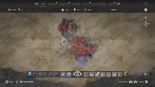
Activating all Metro Stations also get you two trophies/achievements. You receive Tunnel Entrance for activating your first Metro Station and Tube Map for activating all of them. There are 10 Metro locations in total spread across Old Villedor and the Central Loop.
We’ve already detailed how to fast travel in another guide, but to use the system, you need to know where the Metro Stations actually are so you can restore their power. If you want to find them yourself, you can always use your Binoculars — or you could use the Metro Station map below.
I’ve based Metro Station locations on their distance from key Dying Light 2 story locations where possible.
Dying Light 2: All Metro Station Locations

Old Villedor Metro Stations
- Houndfield: Hayward Square
- 330 meters west/northwest of the Bazaar
- Trinity: The Holy Trinity
- 15 meters northeast of the Bazaar
- Horseshoe: No Metro Station.
- Quarry End: Main Terminal Station
- 270 meters south of the Bazaar
- Come here as part of the campaign
Central Loop Metro Stations
- Downtown: Downtown Court
- 485 meters northwest of the Fish Eye
- Come here as part of the story
- The Wharf: Waterside
- 315 meters north/northwest of the Fish Eye
- 278 meters south/southwest of the PK Floating Fortress
- New Dawn Park: Newalls Crossing
- 80 meters south of the Fish Eye
- Garrison: VNC Tower
- In VNC Tower Square (west of the tower itself)
- 550 meters southwest of the Fish Eye
- Newfound Lost Lands: No Metro Station.
- Lower Dam Ayre: South Loop
- 480 meters southeast of the Fish Eye
- About 330 meters southwest of the Church of Saint John of God (across the water).
- Muddy Grounds: King William Bridge
- 375 meters east of the Fish Eye, near the water. The King William Bridge leading to Saint Paul Island is just barely southeast.
- Saint Paul Island: Cathedral
- Just barely east of the Saint Paul Cathedral
Those are all of the Metro Stations and their locations in Dying Light 2. Activate these as soon as you can to unlock more fast travel points around the map. It will make getting from story mission to story mission that much easier in those times you’d rather not run through a horde of infected — especially at night. For more tips and locations maps, head over here for more DL2 content.


Published: Feb 2, 2022 10:15 am